Geology of the Sierra Cobre
Geological Team of Sandy Stone and Rock Eskuhl
Introduction
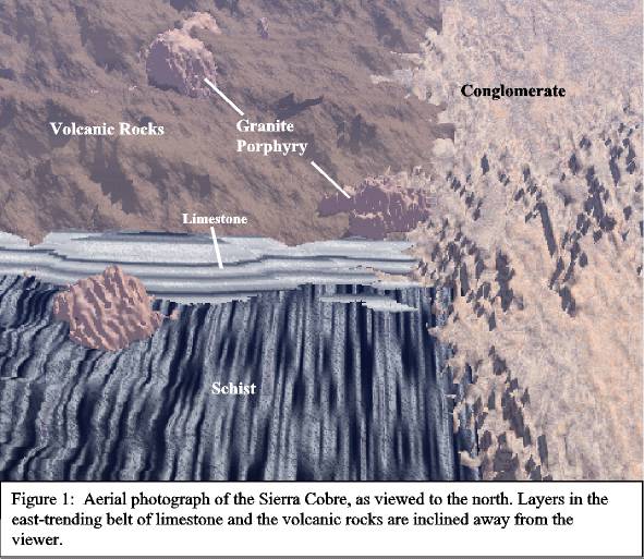
The geology of the Sierra Cobre was mapped by a team of four geologists during March of this year. A member of the team walked every major ridge and stream valley, noting the distribution of rock types, geologic structures, copper mineralization, and alteration of the rocks due to the passage of hot fluids related to the copper mineralization. The resulting geologic map has the following five major rock units (from oldest to youngest): Schist of Precambrian age (older than 550 million years), Limestone of Paleozoic age (550 to 240 m.y.), Volcanic Rocks of middle Mesozoic age (~160 m.y.), Granite Porphyry of Early Cenozoic age (~55 m.y.), and Conglomerate of Middle Cenozoic age (~25 m.y.). Geologically, the area consists of an east-west belt of limestone that separates schist to the south from volcanic rocks to the north (Figure 1). Cutting through these rocks are three granite porphyry bodies, hereafter referred to as the southern, central, and northern granite porphyries. They are called porphyries because they are an igneous rocks with larger crystals in a finer grained matrix. In the eastern part of the area, the schist, limestone, volcanic rocks, and granite porphyries have been buried by a younger conglomerate. Please refer to the geologic map and cross sections while reading this report.
Precambrian Schist
Schist of Precambrian age is oldest rock unit and occupies much of the southern half of the area. It is a layered, dark gray and black rock with abundant platy mica minerals. It was produced by metamorphism (increased heat and pressure) of fine-grained (muddy) rocks, and the layers have been folded and tilted on end (Figure 2). The schist was formed at about 1.7 billion year ago based on age determinations (using the radioactive decay of uranium to lead). The schist generally does not contain much copper mineralization or alteration related to mineralization, except near the southern granite porphyry. It evidently was not a very favorable host for copper mineralization.
Paleozoic Limestone
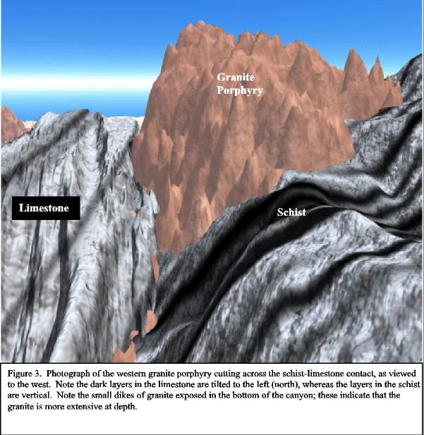
Paleozoic Limestone was deposited over the upturned and eroded layers in the schist (Figure 2). The base of the limestone is an unconformity, an old erosion surface where the schist layers were eroded and exposed before burial by the limestone. The limestone is clearly younger than the schist because it (1) is on top, (2) contains pieces of the underlying schist, and (3) contains fossils that are much younger than the known age of the schist. The limestone is various shades of gray and contains marine fossils, such as corals and clams, that imply its formation in a shallow, warm sea. Layering (bedding) in the limestone is inclined at about 45 degrees toward the north (Figure 3), so this rock projects at depth beneath all the area to the north. It is a very favorable rock for copper mineralization, being very altered and mineralized at the surface within 1 km of the southern and central granite porphyries.
Mesozoic Volcanic Rocks
Volcanic rocks of Mesozoic age overlie the limestone and occupy much of the northwestern part of the area. Lava flows, ash beds, and volcanic mudflows that compose the volcanic rock unit have layers that dip 45 degrees to the north (Figure 4), parallel to the underlying limestone. The volcanic rocks are on top and younger than the limestone, but are older than the granite porphyries because they are cross-cut by dikes and the main bodies of granite porphyry (Figure 4). Also, the volcanic rocks are moderately baked, mineralized, and altered next to the granite porphyries. Age determinations on the volcanic rocks, using the radioactive decay of potassium to argon, are 160 m.y., and indicate that the volcanic rocks are much older than the granite porphyries. The best mineralization at the surface is on the northeast side of the northern granite porphyry, near some small unmapped granite porphyry bodies that probably connect with the main granite porphyry at depth. Other significant mineralization is on the west and north side of the central granite porphyry.
Early Cenozoic Granite Porphyry
Three bodies of granite porphyry cut the schist, limestone, and volcanic rocks. The granite porphyries cut through the layering in the other rock units and are evidently nearly vertical, pipelike bodies (Figure 3). Based on this relation, the granitic magmas probably were injected after the limestone and volcanic rocks had been tilted to the north. Smaller dikes and irregular masses of granite porphyry occur next to the main granite porphyry bodies, and may indicate that these three granite porphyry bodies become larger at depth, possibly even connecting (Figure 4). Copper mineralization in the area is centered on each of the three granite porphyry bodies. Each of the granite porphyries is highly altered and contains moderate amounts of copper minerals, but many of the surface exposures evidently have been weathered and leached of copper by downward-moving groundwater (derived from rain). The leached copper could have been reprecipitated in a nearly horizontal enriched zone at depth when the downward moving, oxidized water encountered more reducing waters down at the water table. Good copper mineralization, therefore, might exist at depth, especially if such an enriched zone in the granite porphyries and adjacent rocks was protected from erosion by some overlying rock unit.
Middle Cenozoic Conglomerate
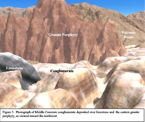
Conglomerate of middle Cenozoic age occupies most of the eastern third of the area. It is composed of consolidated sand and gravel and was deposited by small streams originating on bedrock to the west. Sedimentary layers in the conglomerate are nearly horizontal, dipping very gently to the east, away from the bedrock areas. Based on exposures along the eastern side of the central granite porphyry (Figure 5 and Figure 6), the conglomerate overlies the older rock types as a thin layer. Gravity measurements indicate that the conglomerate generally is less than 500 meters thick and is thinnest close to the bedrock. The base of the conglomerate is an old erosion surface (unconformity) where the underlying limestone and volcanic rocks were tilted and beveled by erosion before the conglomerate was deposited. The conglomerate contains pieces of copper-rich rock, so the main episode of copper mineralization must be older. Also, some gravel pieces in the conglomerate were leached before they were incorporated into the conglomerate, so some enrichment probably occurred before the conglomerate was deposited. Finally, the conglomerate may have buried a fault that nearly follows the generally north-trending conglomerate-bedrock boundary; this fault is interpreted to have down-dropped rocks east of the fault. The main evidence for this fault is the presence of fractured and shattered bedrock right where the rocks get buried by the conglomerate. If this fault exists, it would have made the limestone belt, which has a northward tilt, be offset a short distance to the south on the west side of the fault.
Recommendations for Exploration
The key areas to explore are clearly next to the three granite porphyry bodies. Where these porphyry bodies are near the limestone belt might be especially favorable. When exploring this region, consider the tilt of the various layers. Also important is the geologic history, both before and after the granite porphyry magmas were injected in vertical pipes. If we told you more, it might spoil the fun. So good luck!
© Stephen J. Reynolds, Dept. of Geology, Arizona State University