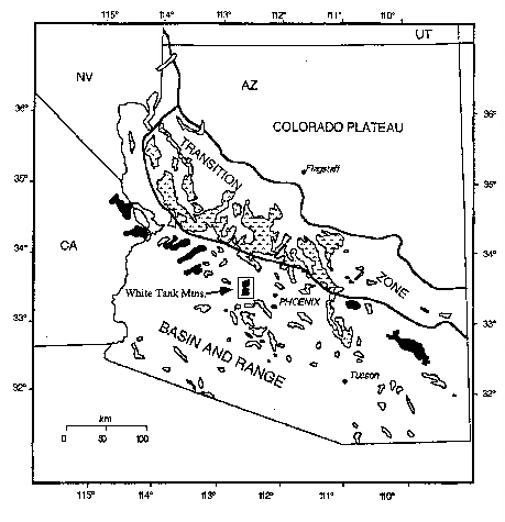
 Figure 1. Map of Arizona
showing the three geologic provinces, Proterozoic outcrops (in
stipple), metamorphic core complexes (in black), and the location
of the White Tank Mtns. [From Alter 1994].
Figure 1. Map of Arizona
showing the three geologic provinces, Proterozoic outcrops (in
stipple), metamorphic core complexes (in black), and the location
of the White Tank Mtns. [From Alter 1994]. OVERVIEW
The White Tank Mountains lie 40 kilometers west of Phoenix
Arizona (figure 1) . The range is within the basin and Range
Physiographic province and they contain tertiary rocks and
features commen in the basin and range. The rangfe also
contains Proterzooic metamorphic and igneous rocks that are
closely related to the Arizona Transition Zone.
In the Early
Proterozoic, central Arizona lay along an active margin at the
southeastern edge of the North America continent.
Continental crust was developed along this margin through
magmatism, NW-SE directed compression and accretion.
These events are documented in the White Tank Mountains by the
presence of syn-tectonic felsic and intermediate plutons, a
penetrative NE-trending foliation, and the folding of this
NE-trending foliation.
The
Tertiary-Cretaceous plutons found in the range were probably
implaced as part of the widespread plutonism associated with the
Larimide orogeny. The range was brought up to the surface
in mid-Tertiary time as part of the lower plate of a detachment
fault system (figure 2). This extension event is documented
by a mid-Tertiary foliation, lineation and mylonites in the
eastern part of the range and by exposure of the detachment fault
itself on the western edge of the range.
To better understand both the Proterozoic
and Tertiary features, we mapped the range at 1:24000
scale. We used TIMS (Thermal Infrared Multispectral
Scanner) and NS001 (an airborne Landsat simulator) imagery to aid
in the mapping process. Hardcopy images were brought in
field to help locate lithologic contacts. Samples from the
mapping area were used to obtain thermal spectra and thin section
grain counts of the rock units. This data was used to
evaluate the effectiveness of the remote imagery in
distinguishing mineralogical differences in the rocks.
Figure 1. Map of Arizona
showing the three geologic provinces, Proterozoic outcrops (in
stipple), metamorphic core complexes (in black), and the location
of the White Tank Mtns. [From Alter 1994].
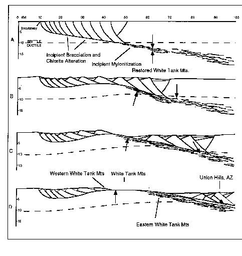
Figure 2. A diagram showing the stages in the formation of the White Tank Mtn. metamorphic core complex [After Spencer and Reynolds, 1989 and Alter, 1994]. P-T indicators from mylonites in the eastern part of the range indicate that these rocks were 11-14km deep at the onset of extension. With the shallow dip (~10 degrees) of the fault, this would indicate that the rocks in the range have been transported 40-50 km to the west and 10-15 kilometers up. This movement would place the original location of the range under the Union Hills, north of Phoenix.
Bedrock Geology Project
Abstract
Overview
Proterozoic rock units
Proterozoic Structures
Remote Sensing techniques
References and
Acknowledgments
Geology and Web pages by Steven Wood and Stephen J. Reynolds, Dept. of Geology, Arizona State University, Tempe, AZ -- July 1998