Remote Sensing Imagery
 Both TIMS (Thermal Infrared
Multispectral Scanner) and NS001 imagery were used in the mapping
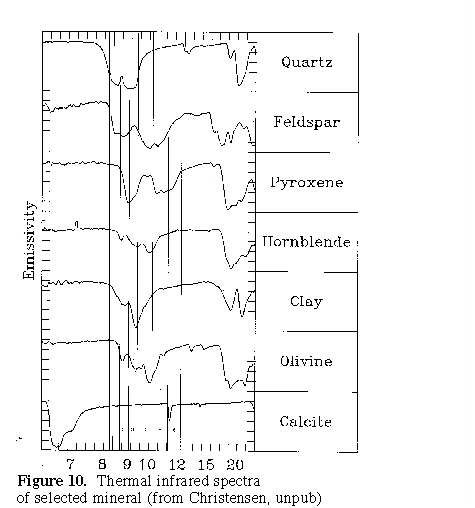
process. The TIMS imagery can be used to distinguish
differences in silicate composition (figure 10), making it very
useful for identifying lithologic contacts. Field mapping is
still necessary to identify which lithologic contacts are
important (such as rock unit boundaries) and to identify
structural features such as fabrics and shear zones.
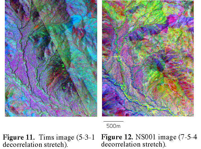
The NS001 imagery was used to define Quaternary surfaces and the
bedrock-alluvium contact. Images from both of these
instruments have a resolution of around 5m, allowing them to pick
up small scale variation in composition. Figures 11 and 12
show the same area with the TIMS and NS001 scanners
respectively. Figures 13 and 14 compare the
tims imagery to the geologic field map and spectral data from
collected field specimens. Figure 15 is a image drape
over digital topography of both the TIMS imagery and the geologic
map.
Both TIMS (Thermal Infrared
Multispectral Scanner) and NS001 imagery were used in the mapping
process. The TIMS imagery can be used to distinguish
differences in silicate composition (figure 10), making it very
useful for identifying lithologic contacts. Field mapping is
still necessary to identify which lithologic contacts are
important (such as rock unit boundaries) and to identify
structural features such as fabrics and shear zones.
The NS001 imagery was used to define Quaternary surfaces and the
bedrock-alluvium contact. Images from both of these
instruments have a resolution of around 5m, allowing them to pick
up small scale variation in composition. Figures 11 and 12
show the same area with the TIMS and NS001 scanners
respectively. Figures 13 and 14 compare the
tims imagery to the geologic field map and spectral data from
collected field specimens. Figure 15 is a image drape
over digital topography of both the TIMS imagery and the geologic
map.
Introduction Page
Geologic Map
Bedrock Geology Project
Abstract
Overview
Proterozoic rock units
Proterozoic Structures
Remote Sensing techniques
References and
Acknowledgments
Geology and Web pages by Steven Wood and
Stephen J. Reynolds, Dept. of Geology, Arizona State
University, Tempe, AZ -- July 1998