Exercise 2A: Fill in the worksheet where asked.
New River Mesa – All the questions for this area are based
on using the paper copy of the map, not on any materials here.
If you get stumped and want to see this map in 3D, check out the
New River Mesa topographic panorama movie.
This file is large (3MB) and takes a little time to load. Click and drag sideways or up and down
to move around; the shift key zooms in and the control key zooms out.
|
Images
of the New River Mesa area.
Follow this link if you want to see some photos of your map
area. You don't need to answer any specific questions. New
River Mesa is just north of Phoenix. |
Cat Mountain – Some questions are based on the paper map
and others use the links below.
The
Cat Mountain TopoNumber movie has small red numbers
positioned on specific topographic features. Use the paper map
to find the name associated with each number. This file is
large and takes a little time to load.
If you want to see this map in 3D, check out the
Cat
Mountain topographic panorama movie. This file
is large (3 MB) and takes a little time to load.
Click and drag sideways or up and down to move
around; the shift key zooms in and the control key zooms out.
 |
Images of the Tucson Mountains.
Follow this link if you want to see
some photos of your map area. You don't need to answer any
specific
questions. The Tucson Mountains are west of Tucson. |
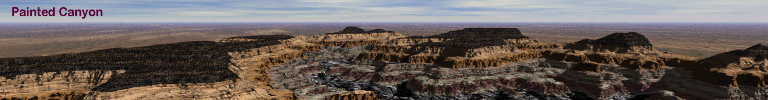
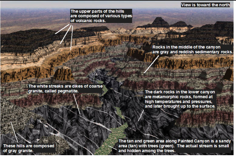
Exercise 2B: Bring up the two images below:
(1) the Painted
Canyon explanation image, which points out a few of the
key features in Painted Canyon. You do not have to do anything
with these for now, but knowing what these features are will help you
later. This view is looking to the north from the south edge of the
map
(2) the named
features image and follow the instructions in your lab
manual. This view is looking to the north from the south edge of
the map
If you need to examine the topography of
Painted Canyon, click HERE
to view a movie where contours are draped over topography
(it's a big file and takes a little bit to load). Click
and drag sideways to spin and up-down to tilt the view.
Exercise 2C: This exercise in evaluating slopes is
designed to be done entirely with the map on your worksheet, but you
can visit the two links below.
-
Click on the maps button to the left, and look
at any of the maps showing slopes.
-
Click on the overviews button or panorama button to get a
3D perspective of different areas of Painted Canyon, including whatever area
you select for your colony.
Note: There is no link back to this page and probably no need to return
here, but if you want to revisit this page you can click the Back
button.
|