|
|
|
|
|
|
|
|
|
|
|
|
| Use your Back button to return to this page. |
|
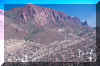
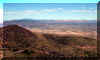
Exercise 10B: Tilted Plane Movie: This week's geologic maps have geologic layers intersecting the Earth's surface. Use this movie to see how rock layers intersect the surface, depending on the direction in which the layers are titled. Click and drag up and down to tilt the layer. Strike and Dip Movie: This week's geologic maps use strike and dip symbols to show the orientation of a rock layer. In this movie, a rock layer is represented by a wooden plank in a barrel (or hot tub) of water, with a strike and dip symbol on the plank. The longer line represents the direction of strike and is always parallel to the water line, because the strike represents a horizontal line. The smaller line indicates the direction of dip and is perpendicular to the strike line; it shows the direction in which the layer is inclined. (This file is large and takes a little time to load.) Complete the Interactive Geologic Blocks module to visualize how layers, folds, faults, and intrusions are expressed on the surface and in the subsurface. These features are present in the areas (Superior and Jerome) you'll study today. Exercise 10C and 10D: Follow the links below to see images of each area. Also, you can look at the topography of the area by choosing the "topography" link listed in the Chapter 10 folder in the Start menu.
|
||||||||||
|
|
|
|
|
|
|