Welcome to the actual Gallery, which has links to QuickTime Virtual Reality (QTVR) movies of the interaction of layers with topography. Each movie consists of a 3D perspective of the map area that the user can rotate using the mouse to view the area from any direction. For each QTVR object movie, click and drag the mouse sideways to spin the 3D terrain to view it from different perspectives. Some movies also have other things happen when you click and drag vertically, such as gaining a perspective from a higher or lower elevation or making a terrain more or less transparent.
To use this site you will need QuickTime installed on your computer, either as a plug-in for your browser or as a stand-alone application to run downloaded files. To access a movie, click on the link below to bring up the QTVR movie for that area. Alternatively, you can download the file to your computer and run QuickTime as an application separate from your browser. I recommend that you download the files and run QuickTime independent of your browser because the QuickTime plug-in isn't consistent about the size it displays the movies and also causes some odd distortions. To rotate the movie, click and drag your mouse to either the left or the right. Some movies also permit you to tilt the terrain up or down by clicking and dragging your mouse up and down. The movies begin with a perspective viewed toward the north (the little red triangle). Not all links below are active, yet.
Caution: The QTVR movies are mostly 500K to 3 MB, and so may require 10 or more minutes to download on slow Internet connections. I made the movies as small as I could without sacrificing quality and usability. If you want a quicker view, check out the single 3D image instead. Contour intervals are mostly 30 meters. Use your BACK button to return to this page.
|
What Movie Shows |
Link to Movie |
| Layer in terrain you can rotate, and tilt to two different elevations | Layer in terrain (Mt. Hiller, Utah) |
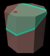
| Layer in an octagon you can rotate, and vary the dip of the layer. The red dot is just to see that it's the octagon that's rotating, not the layer. | Layer in octagon |
| Similar to above, but octagon is partially transparent so you can see the internal layer. | Layer in octagon -- Partially transparent |
| Layer in octagon, but with a fixed 30 degree dip, but ability to switch back and forth from opaque to transparent octagon | Layer in octagon, 30 degree dip |
| Layer in terrain you can rotate and tilt to two different elevations | Layer in mountain and low terrain |
| Layer in terrain you can rotate, but dragging vertically changes between three different amounts of transparency | Layer in mountain and low terrain -- Partially transparent |
| Gently dipping layer in a valley near Lake Powell, Utah | Layer near Lake Powell |
| Caution: The movie below is large (6 Mb), so do not try to download on slow Internet connections. | |
| Layer in terrain you can rotate, and tilt to six different elevations (angles of perspective, from 75 to zero degrees) | Layer in terrain (Mt Hiller, Utah), with 6 angles of perpsectives |
Return to Apparent Dip Home Page
All materials are copyright ©2001 by Stephen J. Reynolds, but can be used freely for educational, noncommercial uses, as long as the source is cited. If you use the site, tell me, because it's a nice thing to do.
![]() Arizona
Geology 3D -- The Arizona Geology 3D website consists of QuickTime Virtual
Reality (QTVR) movies of the Geologic Map of Arizona draped over digital
topography for each 1° X 1° quadrangle.
Arizona
Geology 3D -- The Arizona Geology 3D website consists of QuickTime Virtual
Reality (QTVR) movies of the Geologic Map of Arizona draped over digital
topography for each 1° X 1° quadrangle.
![]() 3D
Geologic Map Gallery -- QTVR movies and images of classic geologic maps
draped over digital topography
3D
Geologic Map Gallery -- QTVR movies and images of classic geologic maps
draped over digital topography
The Hidden Earth -- Visualizing Subsurface Geology -- These images help students and others visualize subsurface geology. It's part on an NSF-funded project we've begun.
Painted Canyon -- A Geologic Wonderland -- These images, done with Bryce4, are of an imaginary, but representative, Southwestern canyon. They are used in our Intro geology lab. Some of the files are large (not very compressed), especially the cool QTVR panoramas (pivot 360 degrees).
Geologic Scenery Images -- Cool images of how tilted layers interact with topography and more.
Arizona Geology Virtual Tourist -- Click your way through Arizona scenery
Steve Reynolds Home Page -- Lots of other stuff related to geology, Arizona, and geoscience education
Page created by: S. Reynolds