The Structure Map 3D website contains 3D perspectives of geologic features on digital topography. Most images are QuickTime Virtual Reality (QTVR) object movies, where you can spin the 3D terrain to view it from different perspectives. The topography is derived from Digital Elevation Models (DEM's) of real places, but the geology depicted is invented (not real) to illustrate important principles of structural geology. The geologic relations shown in most movies are greatly simplified, such as a single layer with a consistent orientation. Others are more complex and challenging. Some movies also have other things happen when you click and drag vertically, such as gaining a perspective from a higher or lower elevation or making a terrain more or less transparent. The collection of movies in this site, from simple to complex, is intended to help students learn to draw contacts on topographic contour maps (included), generate simple to complex geologic maps, and construct geologic cross sections.
Enter the Structure Map 3D Gallery
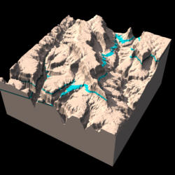
The link below is to a cute little, and I mean little, movie
to see what the bigger ones will be like.
(click and drag the mouse up and down in the movie window)
Tiny Version of QTVR movie is not active yet
Some similar or related images are in the Gallery of Apparent Dips
Visit the Structure Map Information Page to see where we got the data, how we constructed the movies, and who helped fund it. This link isn't active yet either.
All materials are copyright ©2001 by Stephen J. Reynolds, but can be used freely for educational, noncommercial uses, as long as the source is cited. If you use the site, tell me, because it's a nice thing to do.
![]() Arizona
Geology 3D -- The Arizona Geology 3D website consists of QuickTime Virtual
Reality (QTVR) movies of the Geologic Map of Arizona draped over digital
topography for each 1° X 1° quadrangle.
Arizona
Geology 3D -- The Arizona Geology 3D website consists of QuickTime Virtual
Reality (QTVR) movies of the Geologic Map of Arizona draped over digital
topography for each 1° X 1° quadrangle.
![]() 3D
Geologic Map Gallery -- QTVR movies and images of classic geologic maps
draped over digital topography
3D
Geologic Map Gallery -- QTVR movies and images of classic geologic maps
draped over digital topography
The Hidden Earth -- Visualizing Subsurface Geology -- These images help students and others visualize subsurface geology. It's part on an NSF-funded project we've begun.
Painted Canyon -- A Geologic Wonderland -- These images, done with Bryce4, are of an imaginary, but representative, Southwestern canyon. They are used in our Intro geology lab. Some of the files are large (not very compressed), especially the cool QTVR panoramas (pivot 360 degrees).
Geologic Scenery Images -- Cool images of how tilted layers interact with topography and more.
Arizona Geology Virtual Tourist -- Click your way through Arizona scenery
Steve Reynolds Home Page -- Lots of other stuff related to geology, Arizona, and geoscience education
Page created by: S. Reynolds