This page has links used in my NAGT Distinguish Speaker tour and NSF CCLI Workshop, most being to 3D perspectives about the the Geology of Arizona, Landscapes of the Southwest, structural geology, science-education reform, and using Bryce5 to illustrate geology. Most of these materials were built as part of the Hidden Earth and Hidden Earth Curriculum Projects, funded by NSF.
Topographic Files
Shader movie of valley -- Drag vertically to change from a flat contour map to shaded relief
Contours draped over digital topography -- Simple valley, spin and tilt QTVR movie
Contours draped over digital topography -- New River Mesa; spin and tilt QTVR movie
Contours draped over digital topography -- Crater Lake, Oregon; spin QTVR movie (entire 15 minute quad)
Contours draped over digital topography -- Crater Lake, Oregon; spin QTVR movie (just the southern half)
Topowater -- Drag vertically to raise a water plane, coinciding with contours
Toponumbers -- Spin to view from different perspectives (print out topographic base map from Topo Gallery to have students locate the numbers on map)
Topo Profiles -- Drag vertically to cut successive profiles
I have lots more of these, but the Dept is upgrading its web server to make room for all my new movies. Visit the Gallery of Virtual Topography for many other examples and kinds of files.
Interactive Block Diagrams
Geologic Block Diagrams, ala QTVR Object Movies (move mouse sideways to spin the block and up and down to make block more ore less transparent) -- Files are 500Kb to 1-2 Mb -- I'll get them smaller soon.
Structure Map 3D
Gently dipping layer interacting with topography -- Drag horizontally to spin terrain of Poland Junction (use these with contour base map to have students learn how to map: I have high-resolution versions, and answer keys, if you actually decide to use them-- generally the same file name with "_hr" or "hr" added to the end of the file name before the ".mov" extension)
Anticline interacting with topography -- Poland Junction, Arizona (fairly big file)
Same thing, but with a purple plane projecting out of the ground
Visit the StructureMap3D for more maps, along with the corresponding contours maps, which are great for mapping exercises.
Movies of the Southwest shaded by elevation
Southwest US QTVR Movies -- Big files but great! I have a 13 Mb version too, but not here.
More of these images are available in my Southwest 3D site
Movies Created by Draping Satellite Images over Digital Topography
Warning -- some of these files are large -- look before you leap.
Lake Powell area (near Page) -- MSS satellite image draped over digital topography
NEW -- Arizona Thematic Mapper images draped over digital topography (QTVR object movies). These will be part of AZSAT3D.
World Topography
Shaded Relief of the Entire Planet, land and sea floor, based on ETOPO5 data and my six-tone coloring scheme.
Biosphere 3D
QTVR movies of maps of the Biosphere draped over digital topography in globes that you can spin and tilt. Part of NSF-funded Hidden Earth Curriculum Project. Most movies are several Mb.
Sedimentary Environments
Virtual Field Trips of Invented Places
Painted Canyon -- A Geologic Wonderland! These images, done with Bryce4, are of an invented, but representative, Southwestern canyon. They are used in our Intro geology lab. Some of the files are large (not very compressed), especially the cool QuickTime VR panoramas (pivot 360 degrees).
Treasure of the Sierra Cobre: Virtual field trip and exploration game for porphyry copper deposits.
Virtual Field Trips to Real Places with Captured Representations (photos)
Virtual Field Trip to Papago Park: Photos, Maps, and Instructions - Old, and not quite finished, but representative of the traditional virtual field trip genre.
Arizona Geology Virtual Tourist: Click Your Way Through Arizona Scenery -- Another type of Virtual Field Trip of a real place.
Movies created by draping geologic maps over topography -- a great way to teach geologic maps!
Geologic map of the Hollidaysburg Quadrangle in the Appalachians. One way to turn a flat geologic map into a zoomable, scrollable 3D work of art. Click and drag to pan in that direction, or zoom in and out. Warning -- File is 2.5 Mb and takes time to download, but well worth it.
Geologic map of the Calabasas Quadrangle, CA. Same kind of movie as above. Warning -- File is 3 Mb, but well worth it.
Hickey Mountain, Arizona -- geologic map draped over digital topography (more examples, some of which are good for mapping exercises, are in my Geomap3D Gallery)
New Arizona geologic map draped over digital topography (all the rest, for each 1X1 degree quad, are at the AZGEO3D site).
Durango, Colorado -- geologic map draped over digital topography
Many more movies of this type are in my Geomap3D site.
AZ Geophysics 3D
These images have geophysics data, such as gravity measurements, or geophysically derived data, such as depth to bedrock, draped over digital topography. Only static images are included here, but I also have the movies.
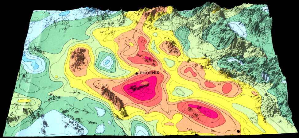
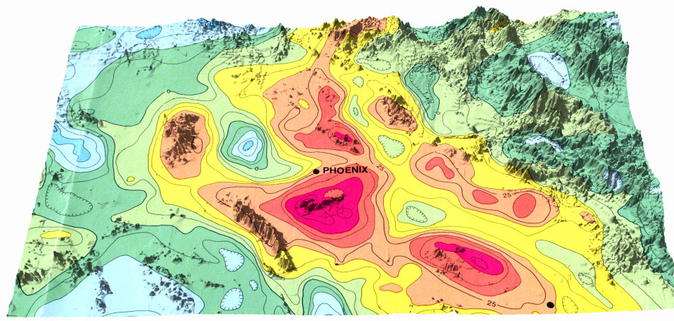
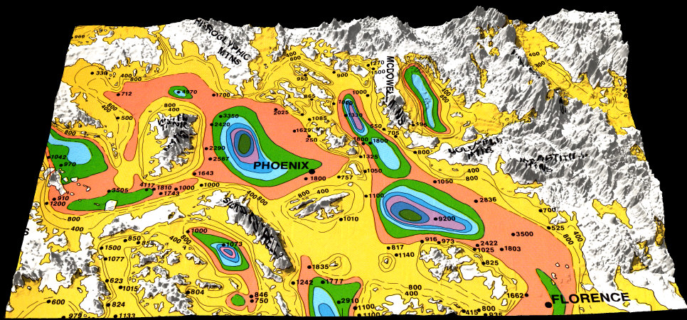
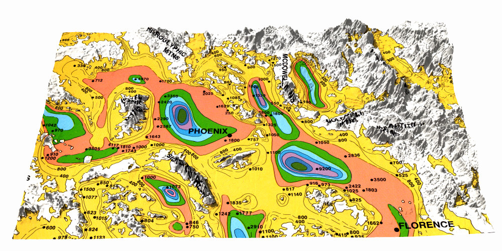
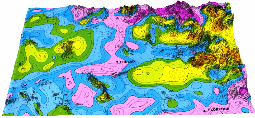
Phoenix East and Mesa West 1x1 degree quadrangles (area centered on city of Phoenix AZ)
Gravity data draped over topography for the Phoenix East and Mesa West 1X1 degree quadrangles. Version with a white background. For novices, warm colors mean stronger gravity due to denser rocks below and cool colors mean less dense rocks. For aficionados, this is from the Residual Bouguer Anomaly Map of Arizona (Lysonski and others, 1980).
Depth to bedrock (in feet) draped over topography for the Phoenix East and Mesa West 1X1 degree quadrangles. Version with a white background. The bulls-eyes are deep basins. This is from Oppenheimer and Sumner (1980).
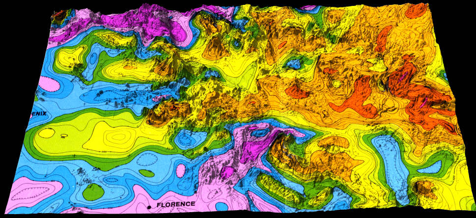
Magnetic data draped over topography for the Phoenix East and Mesa West 1X1 degree quadrangles. Version with white background. Warm colors mean stronger magnetic signal, and cooler colors means less magnetic signal.
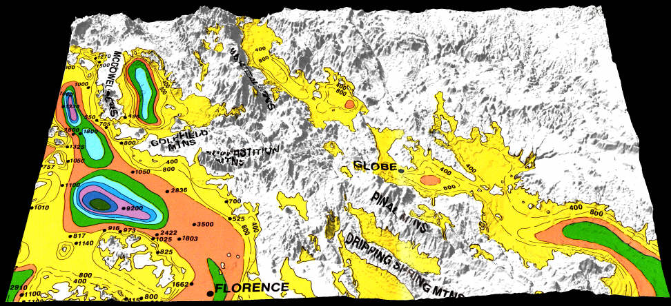
Mesa 1x1 degree quadrangle (area centered on Globe)
Depth to Bedrock map draped over topography for the Mesa 1x2 Quad
Magnetic data draped over topography for the Mesa 1x2 Quad
Gravity data draped over topography for the Mesa 1x2 Quad
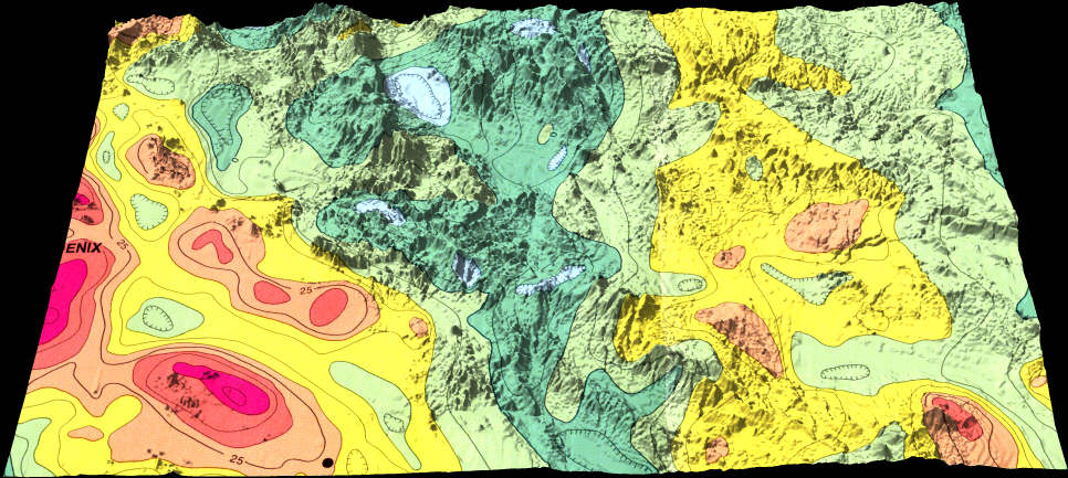
Geologic map draped over topography for the Mesa 1x2 Quad (to compare with the others)
BEST OF ALL -- QuickTime VR movie combining the above four images. Click and drag vertically to compare magnetic data to the geology, the gravity to the depth to bedrock, whatever. This is way cool!!!!
Other Files
Arizona Geological Map: Interactive: A Zoomable Map, Legend, and Photos of Map Units
The Hidden Earth -- Visualizing Subsurface Geology -- These images help students and others visualize subsurface geology. It's part on an NSF-funded project we've begun.
Check out the Geologic Scenery Images I'm doing using Bryce4 and USGS DEM's.
When in doubt, just go to my home page and browse around.
Page created by: S. Reynolds. All images copyright Stephen J. Reynolds, 2000, 2001. OK to use them in classes, but ask me.