Stephen J. Reynolds: Arizona Geology


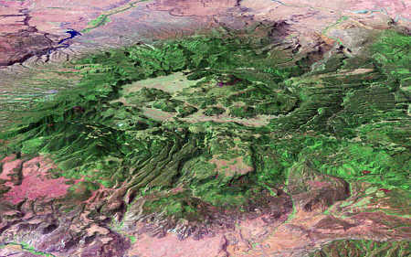
This web site of Steve Reynolds, geology professor at Arizona State University, contains numerous color photographs, 3D perspectives, and information about the Geology of Arizona, Landscapes of the Southwest, structural geology, science-education reform, and using Bryce5 to illustrate geology (like the image above).
NOTE (3/2020): We recreated the Visualizing Topography site and Interactive Geologic Blocks websites as html5-compatible versions, with all movies being mp4 files that will run on students phone, tablets, and comptuers (we had to do this when Apple saddly ditched the QTVR capabilities in QuickTime). These modules are less interactive than the QuickTime versions, which are listed on the links to the left side and which run fine if you use QuickTime 7. The links to the new versions of the odules and the corresponding worksheets are provided in the links below. We are advertising these now because so many of us are having to shift labs to remote-access modes.
Visualizing Topography (html5/mp4 version): Website: http://reynolds.asu.edu/topo_viz_mp4/intro_title.htm Worksheets: http://reynolds.asu.edu/worksheets/
Interactive 3D Geologic Blocks (html5/mp4 version): Website: http://reynolds.asu.edu/blocks_mp4/103_home.htm Worksheets: http://reynolds.asu.edu/worksheets/
The sites listed to the left illustrate various aspects of geology, especially visualizing geology in 3D. The sites use QuickTime Virtual Reality (QTVR) Movies, including QTVR Object Movies, in which you can spin and tilt an object as if you were holding it in your hand, and QTVR Panorama Movies, in which you scroll, pan, or pivot around to get different views around you. Hover the mouse over each button to the left to see a description of the site. Many of the sites contain big movies (some over 10 MB), but I try to warn you in advance.
Virtual worlds, field trips, and other virtual reality files -- This link is the best place to begin to prowl my site; it will lead to links to some of my coolest stuff. If you have participated in one of my NAGT Distinguished Speaker sessions or want to see the materials developed as part of the NSF-funded Hidden Earth and Hidden Earth Curriculum Projects, this is the place!
Featured link -- Strike and Dip QuickTime VR Movie. Tilt and spin a wooden plank, with a strike and dip symbol, in a barrel of water, created by Julia Johnson and me. Warning -- File is 2 Mb and takes time to download.
Biosphere 3D -- The Biosphere 3D site has links to QTVR movies of maps of the Biosphere draped over digital topography in globes that you can spin and tilt. Globes created so far include annual precipitation, soil PH, wind and ocean currents, and many more. Part of NSF-funded Hidden Earth Curriculum Project. Added in September 2002.
AZGeophysics 3D -- This site has QTVR movies of gravity, magnetic, and depth-to-bedrock maps draped over digital topography for each 1° X 1° quadrangle in Arizona. Some special images are listed only in the Virtual Reality page. Part of NSF-funded Hidden Earth Curriculum Project. Added in October 2002.
NOTE: The ASU Geology Department has changed web servers several times and my web address (this page) is now "http://geology.asu.edu/~reynolds/home.htm". You can just type http://reynolds.asu.edu and it will bring you directly to this page.
New Publications: You can download huge (10 to 20 MB) PDF files of the following:
Stereonet 3D -- Stereonet 3D is not yet a full-blown website, but is for now two QuickTime VR movies of a lower-hemisphere with a plane and its pole. Drag the curser sideways to change the strike and up-down to change the dip. The movies are designed to let students explore freely where planes of different orientation and their poles plot on a stereonet. These movies go from 15 to 60 degrees dip, but I plan to make more and move them into their own website. There is a small version (320 X240 pixels; 570K) and a larger version (640 X480; 1.5 MB).
World Topography -- Visit the Virtual Reality page for links to QTVR movies of views of ETOPO5 digital topography of the world colored according to elevation..
AZ Satellite 3D -- Visit the Virtual Reality page for links to QTVR movies of satellite images draped over digital topography, to be done for each 1x1° quadrangle in Arizona.
Sorry, but I don't worry about keeping my biographic information very up to date.
Contacts
Page created by: S. Reynolds.